Web Design: Geoff Roynon |
Last Update: 22nd January 2020 |
This is the Newsletters page for the Horspath Archaeology & History Group.
All newsletters produced by HAHG will be published here, latest issue at the top. All newsletters can be downloaded, in pdf format, below.
◊ |
|
◊ |
|
◊ |
Newsletter No. 3 - January 2020
Download (5.6 MB): Newsletter January 2020 (pdf)
The truly dismal weather and waterlogged land has prevented us from doing any serious field-work these last few months. In the meantime we have been planning for some Spring activity: more of which in later Newsletters.
One noteworthy item is the recent reports in the Oxford Mail that have added to our knowledge and scope of the Romano-British Pottery industry in the Between-Towns Road area of Cowley.
The Local Roman Pottery Industry
Although outside our present Horspath Parish focus, this Cowley kiln-field was a close neighbour of the kilns by Open Brasenose
and those up on the Row Field (next to the modern reservoir) during the Roman occupation and is of interest to us.
Especially as there is good evidence to indicate that much (but not all) of the later Oxfordshire pottery industry had common standards:
particularly in the dimensions of mortaria and domestic pot sizes.
This fact in turn implies some kind of overall business owner(s), or controller(s) involved in setting those standards, at least from about AD 250 onwards. It must have been a profitable family (?) business over many generations, hence one wonders where their headquarters (or perhaps villa) was located. The status display needs of wealthy Romano-British would inevitably meant a luxury building: and lots of Roman bling! An interesting thought...
Thus there would have been connections between our Horspath kilns and other kilns in this area. Management issues apart, if only to access the north-south Roman road between Dorchester and Alchester (close to Wendlebury).
This north-south road, and the various traffic along it would have inevitably impacted the Horspath area, particularly if our ancient track leading off of the main Roman road towards Old Horsepath proves to be (at least) Roman in origin. The materials and manpower needed for firing a series of kilns; woodland management, transport and the supplies of clay alone should have left an impact on our landscape. We just need to find traces of that impact; settlements for workers particularly, and not too far from the kiln-fields.
Geoff has found a link showing the Roman road between Alchester and Dorchester to help readers understand its routing: Alchester and Dorchester link
Alchester itself with its early Roman Fort was the nearest large town along with Dorchester, slightly further away. Both would have had large market-places
and many of their inhabitants would have frequently passed within yards of the Open Brasenose kilns en route to Dorchester and/or Alchester.
And some may have inevitably strayed along our putative track towards what is now Old Horspath and beyond.
Hence our interest in the "Blacklands" field along that track
See links below for the recent excavations at Alchester (and especially the biography of one of the soldiers stationed there!) by the German scholar Eberhard Sauer:
Alchester ExcavationsSauer Info
A lengthy article on the Roman history of both towns is in the History Online version of the VCH, although somewhat dated now as it was written in 1939 and extensive excavations in both towns have been done since then: VCH History Online
New finds relating to the local Roman Pottery Industry.
The 2019 Oxford Mail article links are below:
Roman Pottery in Cowley - Student FlatsRoman Pottery in Cowley - Petrol Station
As an aside, this latter site is interesting as it contains the foundations of the well-known Gibbon's family bakery which was demolished in the building of Cowley Centre. Cath Riley (ne� Gibbons) is a Horspath resident and HAHG member. She remembers the demolition and the family upset that accompanied it!
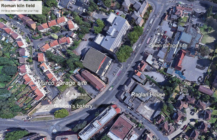
Google Earth cover of latest finds from St Lukes Road
Previous evidence for Roman activity in this area was first noted in 1936 by Prof Atkinson when quantities of 2nd century pottery and waster fragments were discovered during construction of the Cowley Conservative Club.
Subsequent excavations in 1940 recorded a wide range of further evidence. A pottery assemblage of over 15,000 sherds was recovered indicating a gradual increase in production activity from the late 1st century and reaching a peak in the late 2nd century. Production appeared to continue on site to a lesser extent until the late 4th century. Some evidence of human occupation was also recorded at this site, indicated by a rough stone floor with a fragment of a ceramic "cheesepress".
The St Luke's Road site was partially investigated in 1972 by Chris Young during building works for the telephone exchange.
A small quantity of 2nd century pottery, similar to that recovered from the 1939 excavations, was also recorded in a pottery waster tip.
A subsequent watching brief along Between Towns Road in 1981-2 produced further evidence of activity from the 2nd to 4th century including one probable 2nd
century kiln, one probable 3rd century kiln and two other possible sites.
The pottery assemblage dating to this period includes numerous examples of stamped mortaria bearing the mark of Vossullus.
The second phase of activity dated to the 3rd-4th century and comprised two stoke holes, a flue, a kiln, several ditches, a pottery dryer, a waster dump,
and five puddling tables.
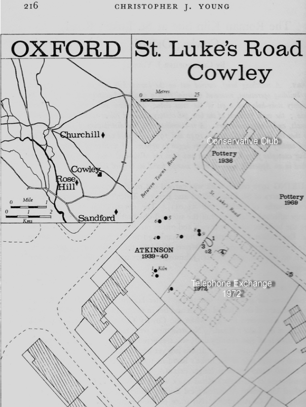
Map of earlier sites from Chris Young's 1973 article in Oxonensia: Vol 38 1973
To the south-west (beneath the present Raglan House), a second stoke hole was recorded, indicating yet another kiln.
Thus the latest evidence from St Lukes/Between Towns Road suggests a progressive southwards expansion or migration of the pottery industry area in the late 3rd to 4th century.
The Oxfordshire Pottery Industry
To put these sites in context for our HAHG readers, the following is a highly abridged extract from an Oxford City Council report entitled:
"OXFORD ARCHAEOLOGICAL RESOURCE ASSESSMENT- 2011 ROMAN"
Compiled by Ruth Beckley and David Radford Version: 28/1/2012
See: OXFORD ARCHAEOLOGICAL RESOURCE ASSESSMENT 2011
The overall report itself is well worth downloading as it gives an up-to-date view of archaeology across the county for all archaeological periods. A truly wonderful resource for local history researchers!
"The local Roman pottery industry is orientated on the Dorchester to Alchester road and encompasses an area of production that stretches
on a north-south alignment from the southern fringes of Otmoor as far as Dorchester, and on an east-west alignment for almost five kilometres.
A summary of the known pottery industry was produced in 1977 by Young providing an overview of the distribution and setting of the industry as well
as a detailed gazetteer of Oxford wares. The volume was updated and republished in 2000 . Young notes at least 30 kilns in the region,
the majority of which were located in the Oxford LAA."
"The broad trajectory of the industry is outlined below:
1st century AD: first evidence of coarse table ware production at the Churchill hospital site (fine grey and oxidised wares).
Late 1st century AD: limited fine ware production is recorded in the Abingdon-Dorchester area including the earliest evidence of white firing clays for mortaria and flagons.
2nd century AD: 100-180. Fine table wares were mainly imported during this period, whereas specialised vessels such as mortaria and flagons were made in the province. The local industry expanded, notably at Littlemore, Cowley and Rose Hill, producing utilitarian reduced wares and also mortaria, flagons in white ware, a range of table ware forms in white and oxidised wares, and also bows and beakers in reduced ware. The mortaria were often stamped. The distribution was mostly local except for mortaria which achieved a distribution extending into the Severn Valley as well as eastwards down the Thames.
Late 2nd- mid-3rd century AD: This was a period of decline for pottery industries generally, however local production survived with some kiln complexes going out of use (Littlemore, Ashurst Clinic) and some new sites established (Blackbird Leys and possibly Littlemore Mount Pleasant). The stamping of mortaria ceased, a pattern seen throughout Roman Britain.
Mid-late 3rd century AD: major changes to the Oxford pottery industry with the introduction of the large scale production of red and brown colour coated fine ware replacing the dwindling supply of imported Samian wares and the increased use of potters stamps (the majority of them "nonsense stamps" as the potters were illiterate: CJP) until the end of the century. It was clear that from AD250 the Oxford industry was one of the major pottery producers of Roman Britain, on a par with other major industries such as the New Forest, the Nene Valley or Mancetter/Hartshill.
Colour-coated wares in the Oxford tradition appear to have been made elsewhere in the province, e.g. at Harston near Cambridge, perhaps by Oxford potters who had migrated.
By the end of the century new sites primarily concerned with the production of mortaria and white oxidised wares were active at the Churchill, the Nuffield Orthopaedic Centre, Oxford School and Open Brasenose. Open Brasenose, Cowley and Rose Hill were also involved in colour-coated ware production. (CJP bold)
During this period there was an expansion in the range of fine wares being produced. A distinctive new range of mortaria was introduced. At the Churchill a range of white-ware flagons and oxidised beakers and jars were made. By the mid-3rd century introduction of white slip and white ware fabrics (so-called parchment wares) can be demonstrated by exports to London and Richborough. Although these wares were widely distributed across southern Britain, the earlier oxidised and reduced coarse wares never extended beyond regional markets.
A significant development was the introduction of red and brown colour-coated ware by c.270.
Late 3rd century AD: the range of white mortaria was simplified; thereafter the character of production did not change significantly during the 4th century. The distribution of Oxford wares achieved greater density and extent during this period, in the south west, south Midlands and East Anglia.
Oxfordshire production came to an end about AD400. The character and speed of the industry's decline is not well understood.
A noticeable feature of the late Roman industry is the consistency of products across a wide area suggesting a level of centralised commercial control."
(As previously mentioned, this would imply a high status owner or controller(s) and perhaps an equally high-status villa: which is perhaps yet to be discovered... Unless the villas at Headington Wick or Wheatley fulfilled that function? My own view is that this is unlikely and a more central site should be sought. CJP)
(NB: Another (shorter) overview of the Oxfordshire pottery industry is provided in: Booth et al. "Thames through Time: The Archaeology of the gravel terraces of the Upper and Middle Thames": The Early Historical Period. Oxford Archaeology Monograph 27. Oxford: Oxford Archaeology. 2007, CJP.)
Old Horspath
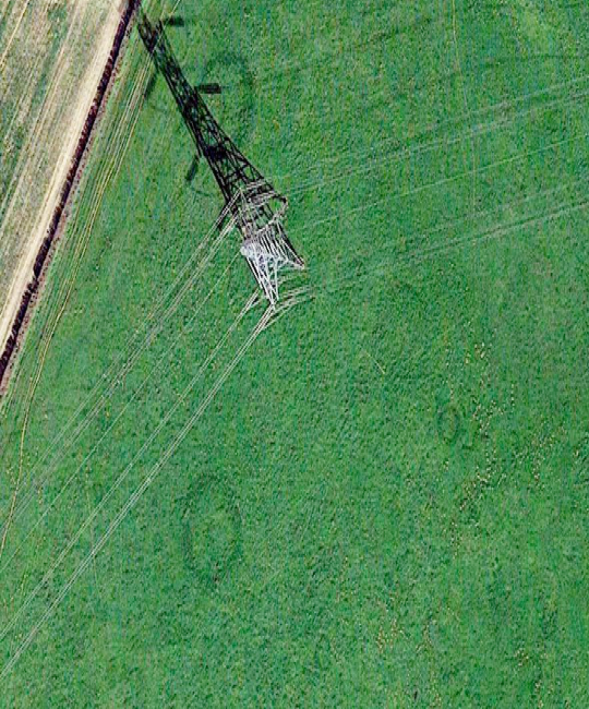
One recent discovery by Sally's son David, is an excellent photograph of the old track as it reaches Old Horspath. It has been a real problem to get good photos of that track. Fine weather and a low sun angle reveal all:
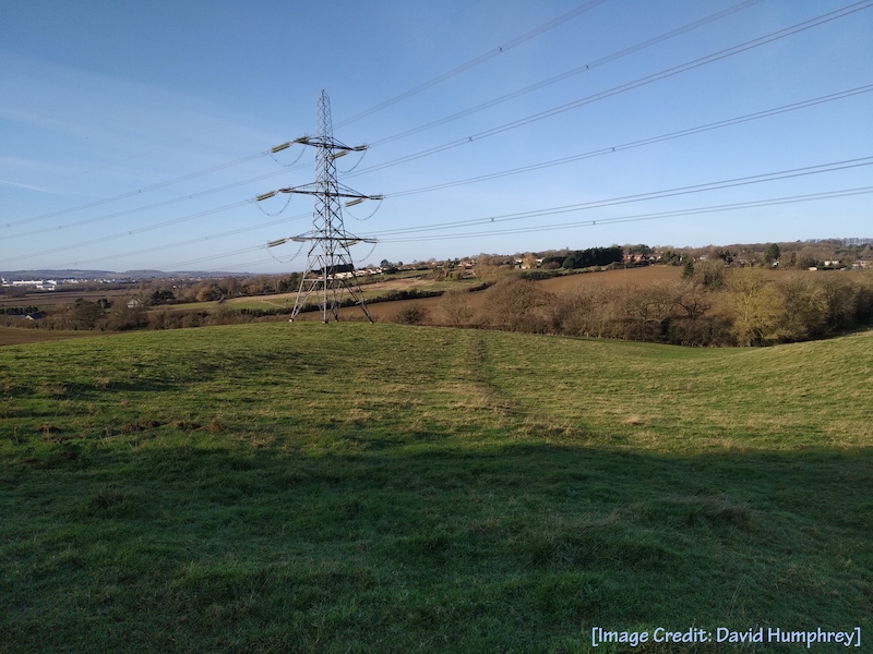
Old Track in Pylon Field
A further development re Old Horspath is our use of DEFRA's LIDAR coverage of our area. For an explanation of LIDAR see: LIDAR Description
Geoff Roynon and myself (with help from Simon Underdown) have been playing with this new imaging system. Geoff recovered a LIDAR map of Old Horspath and distributed it within our group. Eagled-eyed Martin Harris then spotted a curious enclosure-like feature on the map; right where we believe Old Horspath church might have been... When weather conditions improve we will (with Denis Walker's permission of course) try to examine ground features there and report back.
The current resolution of LIDAR cover is fairly crude but we are promised higher resolution cover in 2020/21 so better archaeological details may well emerge.
Do please let us know if you have any questions about any of the above; we'll do our very best to answer them.
Sally and Chris January 1st 2020
Newsletter No. 2 - August 2019
Download (7.6 MB): Newsletter 23-08-2019 (pdf)
The main aim of the Horspath Archaeology & History Group (HAG) is to explore and document the two Horspath's place in the landscape, from the Mesolithic Era up to more recent times.
Sally Humphrey: Group Co-founder and Coordinator
Chris Pym: Group Co-founder and Lead Researcher
Jemma Underdown: Archaeological Advisor
Geoff Roynon: Webmaster and Researcher
Brian Lowe: Post-Medieval Historian
Hello Everyone,
We thought it was time to bring you another update on our recent activities. Do please let Sally know if you have any questions or queries; we'll do our best to answer them as promptly as time allows.
Firstly, and of key importance in reaching a wider interactive audience, Geoff (our webmaster and researcher) has produced a beautiful new website for us and this is now live: Horspath Archaeology and History Group
Please take a look at it and let us know what you think. We are open to all genuine criticisms in order to make our local history more available to anyone with a curiosity about our past.
We particularly want the views of some of our younger villagers. Is there anything we can do to make things more accessible to you? Don't be shy! We (apart from Jemma!) are not professional archaeologists or historians - just ordinary lay people trying to make sense of the village's long and complicated history; and we welcome your views.
Please do forward this newsletter to anyone you feel might be interested.
Newcomers to our group
We would like to welcome Jemma Underdown. She is a resident of the village and is beginning a doctorate on the badly documented and somewhat contentious end of the Roman administration in Britain, and the advent & impact of the incoming Anglo-Saxons. If she is successful our history of that period will need much re-writing.
Jemma is studying at Reading University School of Archaeology under Professor Ken Dark. Professor Dark is one of the leading scholars in this country of this little understood period.
We will be doing all we can to offer her our support as she begins her studies, possibly by using our local knowledge of Roman activity
in this area.
She will also advise us professionally on archaeological matters and help us avoid unnecessary bloopers!
Brian Lowe is well known to all of us from his very popular lectures on the more recent events in Horspath's history
and its personalities, and his long-established university tours.
Essentially, he will be our authority on the post-Medieval period, hence the addition of the word "History" in our group title.
Projects
1) MPRD. Brian is currently preparing a detailed investigation into the reclamation of material from crashed aircraft
from southern Britain during World War 2. It took place at the MPRD (Metal Products Recovery Depot), most of which now lies underneath
the BMW works.
The MPRD is reported to have reclaimed sufficient material for the manufacture of an additional 5000 aircraft during the war: no mean achievement!
Brian is planning to deliver a lecture on this fascinating story in the HUB later on this year and, hopefully, a booklet to accompany it.
2) OLD HORSEPATH: Our research into Old Horspath continues. We are looking into the possibility of a very early history of the track
that leads to it (and beyond?). At the moment, it seems as if this trackway points directly at a small group of possible Bronze Age crop marks,
by way of a possible Roman era building. If proven, then the trackway will have an impressive antiquity!
Also, some new evidence has been found recently along that track by our metal detecting friends (Simon and Toby), namely some badly twisted pieces
of glazing bars from an, as yet, unidentified Roman period building. We now need to find that building! (In hand)
3) OUR FIRST FARMERS?
New evidence of Bronze Age farmers in the Horspath - Garsington Area.
After the recent spell of hot weather, Geoff spotted - via Google Earth - some curious soil-marks along the Horspath-Garsington ridge which he had not noticed before. They are very rare as they depend on exactly the right combination of drought & rain; and vanish quickly:
Garsington Ridge Crop Marks
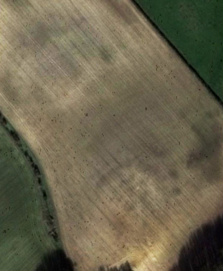
Sally also recently saw some enigmatic circular crop marks on her land:
Pylon Field Crop Marks
In comparing these marks with others in our library files we came to the tentative conclusion that both were Bronze Age barrows,
or hut circles, circa 2000-800BC - but we badly need better aerial photos to date them more accurately.
If we can afford it, a Group drone would be ideal as we would then not have to rely on a combination of the weather and chance satellite coverage
to find & investigate all local crop and soil marks etc. Its deployment could perhaps be useful for other village needs?
The photos (below) for comparison are from Paul Ashbee's "The Bronze Age Round Barrow in Britain" Phoenix House 1960.
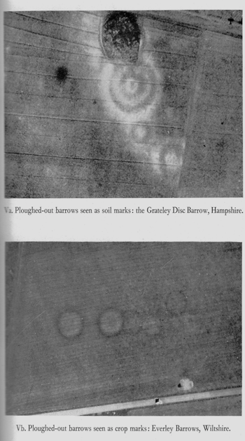
The Bronze Age Round Barrow in Britain
The similarities are fairly obvious. The question is then who were these people?
A recent very large-scale aDNA (ancient DNA) study of peoples of this period showed that the earliest were Neolithic/Bronze Age "Beaker" people (Beaker from the shape of drinking pots found in their graves): Bell Beaker Complex
They were farmers and cattlemen, originating in the Northern Netherlands, and who subsequently settled in southern Britain. These people are very important in the archaeological record as they brought farming to our shores: a truly revolutionary change in food production, and one that gradually displaced the so-called Hunter-Gatherers who had thinly populated these islands since the end of the last Ice Age.
(NB: we have found several scatters of flint-working debris - and curious small white crystals - from the camping sites of Hunter-Gatherer people around Horspath village. See p. 27 of the Old Horspath paper on the HAG website)
Faint local traces of the Beaker People and their descendants' ancient field systems can still be seen in some satellite photos.
And we still have the same basic agricultural practises today.
A four thousand year old tradition... The cattle are thankfully (!) somewhat smaller than back then, and machines do much of the cereal work,
but basically little else has changed. Food for thought...
(Please see our website for the full background to this story)
4) A NEWLY DISCOVERED IRON AGE (?) SETTLEMENT
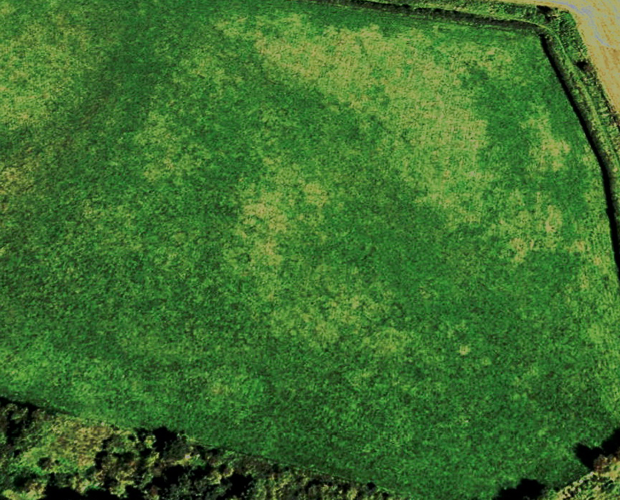
Windmill Field Site - Note hut circles and possible storage pits
We have discovered a new crop mark (above) in the field by the Wheatley windmill. It has all the hall-marks of a small Iron Age village with hut circles and storage pits.
A small trial test pit revealed evidence of a slumped ironstone (building?) wall. Further test pits are planned for later in the year as currently the ground is like concrete. It may be that this is the ancestral settlement of Old Horspath. Or not.. We shall see!
Finally: Please let us know your thoughts on the new website and the way you would perhaps like to be involved with the group: researching on the web; possibly working on test pits. Or perhaps give us leads as to what areas you feel we might cover in future?
NB: Sally is planning to reprint the original Old Horspath paper and the 2 Newsletters in a hard (card) cover. Please let her know if you would like a copy. The approximate cost will be around £12 to £15 per copy for a 25 copy printing in colour, but if less copies are wanted then it will inevitably be slightly more.
Please also visit our website for much more information on all of the above.
And thank you so much for your support to date!
Best Regards
Chris; Sally; Geoff and Brian
Newsletter No. 1 - April 2019
Download (9.3 MB): Newsletter 23-04-2019 (pdf)
Chris and I felt that an update newsletter to the Old Horspath paper was due at last, given some interesting recent research that has shed new light on the old village. As a reminder, the date of our next meeting is Friday May 10th, 7:30 at the Hub. We are hoping you will come and it will help greatly if you could email me back if you are planning on coming. Your comments, challenges and suggestions on any aspect of these investigations are very welcome, as always. Sally.
1) Proof of pre-war antiquity (at the very least least) of the footpath extension from our proposed early road/track from Headington Quarry and possibly as a branch road from the main Roman Road down to the Ridings & across the fields through to Manor Farm and between the Manor House & the Queens Head pub. It's part of a USAF practice reconnaissance photo taken in 1943 (Copyright Historic England Archives) and clearly shows that the footpath is a continuation of our proposed old footpath/track and predates the current meandering footpath through the modern houses. Note that it would appear to be heading across the old Manor House lawn & gardens; thence perhaps across the the old railway line (the making of which would have destroyed that section) and then (we suppose) towards Old Horspath.
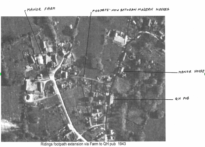
Ridings Footpath Extension
2) (Below). Newly discovered Ordnance Survey mapping of an early track leading out of Lower Horsepath, apparently heading towards Old Horsepath. Taken from the First Edition Ordnance Survey map of this area which was mapped between 1818 - 1825. (If anyone is interested in further research on other areas, microfiche copies of these early OS maps - known as "Surveyors Notes" - are held in the City Archives in St Lukes old church in Cowley.)
It certainly comes off of what is now Gidley Way and would appear to connect laterally to the footpath extension mentioned in item 1 above, before heading out above the Horspath Allotments and across what is now the top of the rear gardens of the houses along the Cuddesdon Road in the direction of Old Horspath. Interestingly, the majority of this track seems to follow the 300ft contour line, adding weight to Ivan Wright's view that it was the "least wet" route without getting caught up on the slopes of Shotover Hill itself. The lower branch of this track seems to be heading for a possible cattle "drink" on the Hollowbrook. I can think of no other explanation for this branch unless anyone has a better idea?
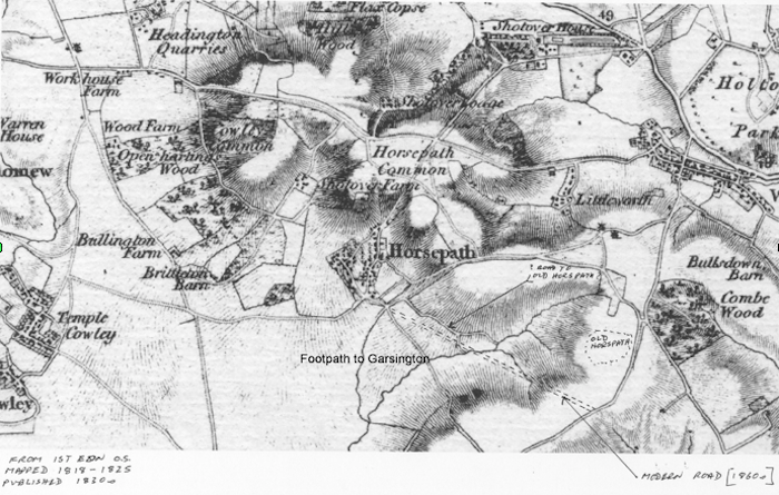
Early Track from Lower Horsepath
3) Field names have long been recognised by archaeologists as indicators of past activity and the local field-name of "Blacklands" on the 1847 Tithe Award has long made us suspicious that something interesting was going on there. The field is directly above the new Savvy building site along the Cuddesdon Road. (See map further below.)
An extract below is from: Blacklands - A Landscape
"Blacklands" Field Names. The name of the field was also of interest. Field names can sometimes give clues to some kind of previous activity. The name "Blacklands" or "Blackfield" has been associated with previous occupation. The origin of the name is obscure, but may have been applied to fields that show signs of archaeological significance because the occupation has darkened the soil or artefacts have been found. Many Roman settlements have been found in fields with this appellation e.g. Cunetio, a Roman town west of Marlborough; and Blacklands, a villa site near Faversham, Kent. There are many more examples, too numerous to be simply accidental; therefore I was interested to investigate the potential of this field at the invitation of the owner, Mr Gordon Hendy. (end of extract)
Hence when we saw that the probable course of the road/track (above) to Old Horsepath leads right through a field known as "Blacklands" bells started ringing. But caveat! Before we assume anything; there can be many other explanations than a villa, such as pottery kilns of almost any period, or industrial activity requiring furnaces such as iron-making: hence the residual black ash contaminating the local landscape. Any other ideas?
The cropmarks in the field alongside are enigmatic & may have been caused by creating modern horse paddock fencing. To solve this conundrum we need to get access to this field with the permission of the owner, to either test-pit or metal detect it, and I understand from Sally that there are new owners who may be open to our investigations. Sally will bring us up to date on this at the meeting.
See sketch-map map and photo below:
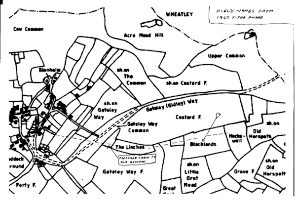
From: "The Landscape of Oxford's Greenbelt" by Digweed and Saunders. OUDES 1981
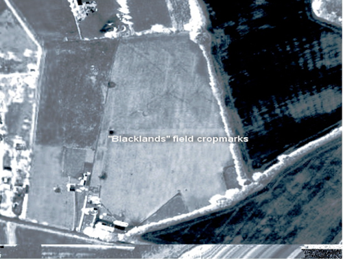
Aerial photo of Blacklands field and showing adjacent crop-marks (copyright Google Earth 2006)
4) Wendy Austen's translation of the entry for the Horsepaths in the 1279 Rotuli Hundredorum has shed fresh light on Old Horsepath Manor's land area at that time. Although Wendy has inevitable reservations about a few of the difficult Medieval Latin words therein, the key point is that looking at the maths of converting the text's yardlands etc into modern acres, it becomes obvious I've committed a classic schoolboy error re the total acreage of the OH manor. Wendy points out to me that "A yardland is roughly 30 acres but may vary locally. I wouldn't like to comment on the size of Horspath nor its exact boundaries, but 8 x 30 is 240 acres roughly." This variation is due to the fact that many early land area measurements are based on crop yields; (i.e., soil fertility), which is very sensible in assessing market and therefore taxable values.
From this, I now think that the total acreage of Old Horspath Manor's land is almost twice the size I'd previously thought, but it now seems probable that OH Manor extended south-west along the Hollowbrook - a natural boundary - beyond the Cuddesdon Road towards Garsington, and then uphill towards Surman's Farm (City Farm) on the Garsington-Wheatley road: i.e., on the present Horspath parish boundary with Garsington. I would guess at perhaps 550 acres for OH, which accords reasonably well with the VCH estimates of the acreage of the two Horspath manors in 1279 (see: British History - Horspath Parish).
However access to the 25 inches to the mile OS maps in the City Archives will give a better estimate as they have the acreages of each individual field listed. None-the-less, in the absence of clear mediaeval records, the true extent of both manors is open to some debate, but in the general scheme of things I feel it is of no great importance at this point in time.
See below for the Old Horsepath Manor's probable boundary; outlined with dash marks:
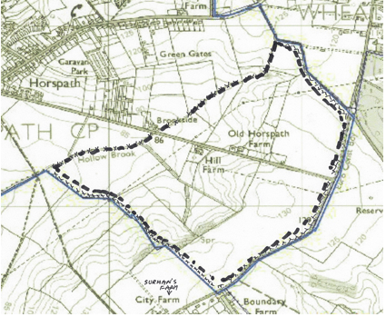
From current OS Landranger map (copyright OS.)
Land ownership and their boundaries have rarely changed, probably since the Iron Age or even earlier, and I cannot trace any record of the overall parish boundary being altered since mediaeval times, and a change of this magnitude would certainly be noted in the VCH (Victoria County History).
Photocopy from original 1279 RH entry:
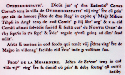
Original 1279 RH entry
Wendy's transcription and translation of the above entry:
OVEREHORSPATHE. Dicunt juratores quod dominus Eadmundus Comes Cornubij 1 tenet in villa of OVEREHORSPATHE viij virgatas terre cum pertinentijs que sunt de honore predicto de domino Rege in capite quod Magister Militie Templi in Anglia tenet de eodem Comitatu pro iiij libris argentijs et x solidijs. eidem Comiti annuatim solvendis faciendis et sectam curie de NORTH OSNEY de tribus septimanis in tres septimanis (?) et servicio regale quantum pertinet ad dimittendum feodum militibus. Afsunt (?) et tenentes in eodem feodo qui tenent viij predictas virgatas terre de Magistro in villenagium faciendo eodem servicia inde pro voluntate sua.
FEODUM DE LA MUSARDERE. Johannes de Scaccario tenet in eadem villa vij virgatas terre et dimidimis cum pertintijs et debet scutagium que currit heredibus.
Translated:
Over Horspath The Jurors say that Lord Edmund, the Earl of Cornwall, holds in the vill[age] of Over Horspath eight yardlands of land with appurtenances which are of the aforesaid estate held of the Lord King, in chief, which the Master of the Knights Templars of England holds in the same County for four pounds of silver and ten shillings to the same Earldom making this payment annually namely [for] suit of Court regarding North Osney of three weeks in three weeks (???) and royal services as much as pertain to half the fee of the Knights. Afsunt(?) and the tenants at the same fief, who hold the aforesaid eight yardlands of land concerning the Master in villenage is doing the same services the Master in villenage Is thereby by his will.
THE FEE REGARDING THE MUSARDERE.- John of Scaccario holds in the same vill[age] seven and a half yardlands of land with appurtenances and owes scutage [for carriage by boat/barge] which he runs(?)
I'm sure Wendy will have further comments on this subject!
Newsletter PostScript Notes.
Toby's presentation to the group of the results of metal-detecting on "Blacklands" revealed Roman pottery and several Roman coins, one of which has been preliminarily identified as a Hadrian (approx AD100 - AD140). Hadrianic coins are rare in this part of the world & seem to have been restricted to army use and in high-status villas, as the early Romano-British economy was not monetarised to any great degree - that came in around towards the end of the 3rd century AD and the rise of the major pottery industry. Therefore if the Ashmolean confirms the coin's date and attribution, it raises many interesting questions: that of who dropped the coin?
Further reading shows that the Dorchester to Alchester road is early: perhaps within 50 years of the invasion (AD 43) and leading directly across Otmoor to the Roman fort/town near Bicester (Wendlebury). Earlier access would have been along the Forest Hill to Islip road, according to Henig's "Roman Oxfordshire" anyway. So, if the coin-dropper came from Alchester (or just possibly Dorchester), it follows that a direct route to "Blacklands" might well be off the main Roman road & then along our proposed track to Old Horsepath and beyond - maybe to the villa at Little Milton? Hence it is possible that our OH track is of Iron Age in origin at least...
To refresh ourselves about Alchester, here's a Wiki extract:
Alchester is the site of an ancient Roman town. The site is not included in any ancient references so the Roman name is not known. However it lies about 2 miles south of Bicester, in the northwest corner of the parish of Wendlebury.
Alchester had a strategic location in Roman Britain at a crossroads on the Silchester-Dorchester on Thames-Towcester road and the Cirencester-St Albans road (Akeman Street). Recent excavations have shown that it was the site of one of the earliest legionary fortresses in Roman Britain after the invasion of 43 AD. The site has been the subject of investigation since 1996, first under the auspices of Oxford University Archaeological Society, then under those of Leicester and Edinburgh Universities.
Military Phase
From the time of the Roman invasion Alchester was in a strategic position in the border region of the Catuvellauni and Dobunni tribes, and in an ideal position to exercise control over wide areas. During the first few years after the invasion, a large legionary fortress of the Legio 11 Augusta commanded by Vespasian was built here. Alchester was situated behind the early military front line of the Fosse Way in an ideal position as a supply base. After the conquest of most of the rest of Roman Britain, the legion moved to Exeter before AD 68 and abandoned the fortress as a military garrison but the town itself continues until the 5th century. The rising water table in the region badly affected the town and there is evidence of substantial drainage work over the centuries.
The Legionary Fortress
Playing-card-shaped enclosures with ditches were shown on aerial photographs taken in 1943-45. Excavations in 1990 focussed initially on the Roman military enclosure near and under the later Roman town, and then on its fortified annex. This proved that the larger enclosure was indeed surrounded by an army-style V-shaped ditch characteristic of a fort.
The spread in time and frequency of early objects and the buildings shows that the fort was more substantial than a normal camp, and existed for a longer time than a temporary camp for use only during the invasion.
Investigation by Eberhardt Sauer of the gate of the annex in 1996 revealed two wooden gateposts preserved in waterlogged conditions for which dendrochronology gives both of them felling dates of between October AD 44 and March AD. The main fortress must have been built earlier and probably in the year of invasion, 43 AD.
The smaller enclosure, with its U-shaped ditch and square corners was atypical for Roman forts, and was interpreted as a parade ground. The presence of this would also support the idea of a fairly permanent military base.
The discovery in 2003 of smashed fragments of the tombstone of Lucius Valerius Geminus, a veteran of the Legio 11 Augusta is significant in that it shows he retired from the legion while stationed at Alchester even though he came from north-west Italy and lived in the vicinity until his death. The fortress must have been well-established and probably associated with a nearby vicus (civilian town).
The inscription reads:
Dis Manibus/ L(ucius) Val(erius) L(uci filius) Pol(lia tribu) Gemi/nus For(o) Germ(anorum)/ vet(eranus) Leg(ionis) [I]I Aug(ustae)/ an(norum) L h(ic) s(itus) e(st)/ he(res) c(uravit)/ e(x) t(estamento)
"To the souls of the departed: Lucius Valerius Geminus, the son of Lucius, of the Pollia voting tribe from Forum Germanorum, veteran of the Second Augustan Legion aged 50(?), lies here. His heir had this set up in accordance with his will."
The size of the fort at 14-15ha including the annex is larger than that estimated for the previous fortress of Legio II Augusta at Strasbourg. Other finds also support the conclusion that this was its legionary fortress soon after invasion of Britain and before it moved to Exeter, and that its commander Vespasian was located here rather than in southern England at this time.
Evidence from coins found at the site suggest army abandonment was likely to have taken place before the death of Emperor Nero in AD 68.
The Town
Outside the western defences, excavation in 1766 of what was then a prominent mound known as the Castle uncovered a sizeable Roman bath. Excavations in 2003 of the town wall near the west gate showed this had been robbed of building stone in post-Roman times, except for two stones that were found in situ and the wall's rubble foundations.
The area bounded by defences, about 25 acres, is almost square, with the earliest defences consisting of a gravel rampart and one or more ditches; later, a stone wall was added to the rampart. The dating of these two phases is obscure. The planning of streets approaches a rectangular grid, uncommon in smaller Romano-British towns. Along the main street, aerial archaeology has revealed a number of narrow, rectangular strip buildings. Near the centre of the town lay a building with a central court, surrounded by a portico on three sides.